Infra
Income and racial disparity in household publicly available electric vehicle infrastructure accessibility – Nature Communications

Nation-wide social disparity in access to public EV infrastructure
Using locally weighted scatterplot smoothing (LOESS) regression and U.S. population data, we find a consistent (nonlinear) positive relationship between income and public EV infrastructure accessibility across four racial/ethnic households (Fig. 1a). In both urban and rural areas, as household income increases, access to the public charging station(s) also increases (the distance to the charging station decreases). Black households experience the least accessibility to public EV infrastructure in rural areas compared to White, Hispanic, and Asian households. In urban areas, Black households are the second least accessible group, followed by White households. Ordinary least squares (OLS) regressions are also conducted to compare accessibility among different racial/ethnic households while controlling for income and yielding consistent results (see Methods and Supplementary Table 6). On average, rural households have less access to EV infrastructure compared to their urban counterparts. These trends remain consistent even when up to 5 charging stations are considered.
a Locally weighted scatterplot smoothing (LOESS) regression curves displaying the relationship between income and the average distance to the N-nearest EV infrastructure among different racial/ethnic households in urban areas. b LOESS regression curves among different racial/ethnic households by average distance to N-nearest EV infrastructure in rural areas. c Increased rates (%) between Nth and (N-1)th nearest EV infrastructure accessibility among different racial/ethnic households and income groups in urban and rural areas. EV public infrastructure accessibility showing the LOESS regression curves by $100,000 interval of the entire sample (n = 118,682,791). The LOESS regression curve, represented by the solid line in the center, shows the predictive value, while the shadow around it represents the 95% confidence interval.
Public EV infrastructure typically contains level 2 and Direct Current (DC) fast charging46. In this paper, we focus on infrastructure accessibility, specifically the proximity to charging stations. Potential bias may arise from consumers’ preferences for DC fast charging stations over level 2 charging stations. To account for this, we undertake three additional robustness analyses to bolster our primary analysis, all of which are detailed in Supplementary Note 1 within the Supplementary Information (SI). One of our analyses introduces an index that accounts for users’ preferences across various charging station types by assigning distinct weights to DC fast charging stations, another by examining the ratio of DC fast charging stations in our core analysis, and finally incorporates the analysis using the Inhabitant-to-Station Ratio through a two-tiered approach. The results consistently align with the overarching trends observed in our core assessment.
We also calculate the percentage increase in distance between the Nth and (N-1)th nearest charging stations for households within each racial/ethnic population in the top and bottom 5% of income. Our results, presented in Figure 1b, indicate that in urban areas, households in the lowest income group experienced a greater increase in distance to additional charging stations compared to those in the highest income group (top 5% of income), regardless of their racial/ethnic background. Interestingly, we find that this trend is consistent for Asian and Hispanic households in rural areas as well. In summary, the results highlight the disparities in accessing additional charging stations based on income and race or ethnicity.
Income and racial disparity in county accessibility gaps in public EV infrastructure
To evaluate equity at the nationwide county level, we quantify two types of accessibility gaps: one related to income disparities and the other centered around racial disparities as our core dimensions of accessibility gaps. We have chosen income and race because they represent two structurally rooted problems. Income is a fundamental metric to measure people’s economic ability and social class. Racial inequality and discrimination is another deeply rooted, systemic problem in the U.S. A vast literature focuses on these two factors19,39,47,48,49,50. More practically, income and race are two key indicators we can observe at the household level nationwide in our dataset.
To measure the first core gap, we use the difference in distance to the EV infrastructure for low-moderate income (LMI) and non-LMI households (Fig. 2a and b). To measure the second core gap, we use the difference in distance to the EV infrastructure for the Black and White households (Fig. 2c and d). In this analysis, we focus on the racial accessibility gaps between Black and White households instead of all types of racial/ethnic households. Our interest in the spatial differences between Black and White households stems from the persisting disparities and inequities faced in accessing social resources, including transportation infrastructure, health, education, and more51,52,53. Here, positive numbers indicate that LMI and Black households experienced larger accessibility gaps (or barriers) compared to non-LMI and White households, respectively. Negative numbers suggest that LMI and Black household experience a lower accessibility gap compared to White households.

a, b: Accessibility gaps between low-moderate income (LMI) and non-LMI households by rural and urban, respectively; c, d Accessibility gaps between Black and White households by rural and urban, respectively. The magenta color scheme shows that LMI and Black households experienced larger accessibility gaps (or barriers) compared to non-LMI and White households, respectively. Vice versa, the green color suggests the opposite. Gray color means no data available or beyond the defined minimum and maximum thresholds of −300 and 300 km, respectively.
As might be expected, we see mixed accessibility gaps between LMI and non-LMI households at the county level in both rural and urban areas. We observe that more counties have LMI households facing accessibility gaps in rural areas (Fig. 2a) than in urban areas (Fig. 2b). 53% of the county had LMI residents experiencing accessibility gaps in rural areas compared to 35% of counties in urban areas. In rural areas, LMI households in counties with accessibility gaps have to travel an average of 2.92 km more to reach EV infrastructure compared to non-LMI households. In urban areas (Fig. 2b), LMI residents in counties with accessibility gaps have to travel more on average to reach EV infrastructure (1.73 km), compared to those LMI residents in counties without accessibility gaps (travel less by 1.55 km). This is consistent with the literature showing that low-income households are more likely to live in the center of the city in the urban areas54,55,56.
The accessibility gaps between Black and White households at the county level are mixed. In about half of the rural areas in counties (49%), Black households have to travel an average of 2.30 km more to reach EV infrastructure than White households (Fig. 2c). While in urban areas, about 34% of counties have Black households experiencing accessibility gaps (Fig. 2d). Although the inequity between different racial households is less pronounced, Black households have to travel further on average when experiencing accessibility gaps relative to their counterparts who do not experience such gaps. Specifically, Black households have to travel 1.20 km more to EV infrastructure, when experiencing accessibility gaps. In contrast, when White households have accessibility gaps, they travel an average of 1.10 km more to the EV infrastructure.
Public resources, specifically the public EV infrastructure, should be equitably accessible to all demographic groups, irrespective of their income, wealth, or racial backgrounds. Our county-level analysis reveals mixed disparities in local access that diverge significantly from previous studies using averages and larger geographies2,57. These disparities underscore the necessity of developing policies tailored to local conditions. Our findings suggest that regions marked in red require more substantial policy support. This stems from the recognition that low-income and Black populations are vulnerable groups. For example, rural areas, depicted in red, necessitate increased support.
Finally, we recognize the existence of various dimensions related to accessibility gaps, encompassing factors like vulnerability, social and economic disadvantage, and educational attainment, among others. In our pursuit of an exhaustive analysis of the accessibility gaps from income and racial dimensions, we conducted an additional investigation by incorporating the Electric Vehicle Charging Justice40 Map Tool, jointly proposed by the Department of Energy and Department of Transportation to explore other equity dimensions. This tool, designed to identify Disadvantaged Communities (DAC) at the census tract level, offers an alternative perspective on accessibility gaps (refer to Supplementary Note 2) between DAC and non-DAC. Our examination revealed strong correlations between our racial accessibility gap and the DAC accessibility gap, as well as between our income accessibility gap and the DAC accessibility gap, both at the county and state levels. It is crucial to underscore that our analyses of income and racial disparities are firmly grounded in individual household data, providing a finer-grained understanding compared to analyses conducted using demographic data at the broader census tract level. This heightened level of detail enhances our confidence in the robustness of our findings, particularly when comparing them with the DAC accessibility gap.
Income and race play different dominant roles in the prediction
Using the LASSO machine learning approach, we explored whether income or race was a better predictor of access to public EV infrastructure accessibility. We find compelling evidence that both race and income significantly influence the accessibility of public EV infrastructure. However, the relative importance of these two factors exhibits geographical heterogeneity, especially in the urban and rural, MUD and SFD settings. One intriguing finding from this analysis is the pronounced association between race and the presence of EV infrastructure in MUD compared to SFD, both in rural and urban settings. In urban areas specifically, race emerges as a more influential factor.
In rural areas, income emerges as a better predictor for accessibility than race in most states. For rural SFD residents, income is a better predictor of EV infrastructure accessibility in 48 out of 50 states (Fig. 3a). The dark green color in the figure represents a negative correlation between distance to the EV infrastructure and income, indicating that households with higher income have better accessibility to EV infrastructure, as they have to travel a shorter distance to reach it. Hawaii and Alaska have different outcomes due to their special features, and they can be considered outliers. However, for rural MUD residents, we start to observe that race plays a more dominant role compared to income in a few states. In 7 out of 50 states (Fig. 3c), race is associated with a positive correlation, and has a higher predictive power compared to income, indicating that when a MUD resident belongs to the Black minority group, the distance to the EV infrastructure increases.

a Rural single-family dwelling (SFD) residents. b Urban SFD residents. c Rural multi-unit dwelling (MUD) residents. d Urban MUD residents. Note that the District of Columbia (DC) is not shown in panels (a) and (c) since all DC residents are classified as urban. The coefficients are color-coded to indicate their direction (positive or negative). When the coefficient estimate of income or race (being Black households) is positive, it means that a higher value of that factor is associated with a longer distance to the nearest electric vehicle (EV) infrastructure, while a negative coefficient estimate suggests the opposite. Equal means coefficient estimates of income and race approximate towards zero at the same time with the increased alphas.
In urban areas, our findings suggest that race increasingly serves as a more important predictor of EV infrastructure accessibility across a larger number of states. For urban MUD residents, 12 out of 51 states demonstrate a positive and stronger association between race (being Black households) and distance to EV infrastructure (Fig. 3d). This could be due to certain reasons in these 12 states: Black households are more likely to reside in urban MUDs, yet their access to public EV infrastructure is considerably limited when compared to White households. This finding aligns with existing literature in that underrepresented groups often find themselves concentrated in impoverished urban areas58,59,60. Therefore, it is crucial to acknowledge potential interaction effects between the spatial location of most public EV infrastructure and the residential arrangement of both Black and White neighborhoods, with a greater proportion of low-income Black households in urban settings.
For a more comprehensive understanding of EV infrastructure accessibility, we extended our LASSO analysis to include four additional outcomes (average distance to 2 nearest stations (DP2)- average distance to 5 nearest stations (DP5)). These outcomes include measures such as the average distance to two nearby stations, and up to five nearby stations. Our findings consistently highlight, in line with the previous discussion, the significance of factors such as income, race, housing type, and location. For a detailed presentation of these findings, please refer to Supplementary Fig. 9–12. The results obtained through our machine learning approach reinforce and are consistent with the conclusions drawn from our previous correlation analysis, which emphasized the importance of income and race as key predictors of EV infrastructure accessibility but also shed light on the access disparities that existed between SFD and MUD. Aligning with the literature that lower-income households, or underrepresented households are more likely to reside in MUD, our results further confirm that in many states, especially in urban areas, Black households experience accessibility issues to public EV charging stations.
Potential contributors to the income and racial disparities in public EV infrastructure
Our previous analysis revealed that accessibility gaps vary widely across different counties. To shed light on the causes of these heterogeneous accessibility gaps, we delve into the potential factors that have a strong correlation with income and racial disparities in EV infrastructure accessibility, employing a regression-based framework in this section. Our approach involves examining the strong correlation between the county-level accessibility gap and a set of predictor variables at the county level. Factors with strong correlations help to explain the accessibility gap. We conduct two separate OLS regressions, with one focusing on the accessibility gap in income and the other on the accessibility gap in race. Our variables derive from a systematic literature review (see Supplementary Note 4) and our methodology can be seen in full detail in the Methods section.
To visually represent the results, we present the estimated coefficients of interest in Fig. 4, and the corresponding table output in Supplementary Table 7. Panels a and b depict the estimated results for the income-based EV infrastructure gap. Our analysis shows that the highway gap is a significant contributor to the accessibility gap, followed by the income gap. The positive association between the highway gap and accessibility gap between LMI residents and non-LMI residents indicates that if LMI lives farther from the highway than non-LMI residents, accessibility to public EV infrastructure will decrease. The negative association between the income gap and accessibility gap indicates that if the income gap between LMI and non-LMI residents increases, the accessibility gap will widen. Moreover, we observe that both the MUD gap and SFD gap contribute to the accessibility gap. However, we note the opposite signs of MUD gaps between rural and urban settings, which can be attributed to the higher number of charging stations located around MUDs in urban areas.
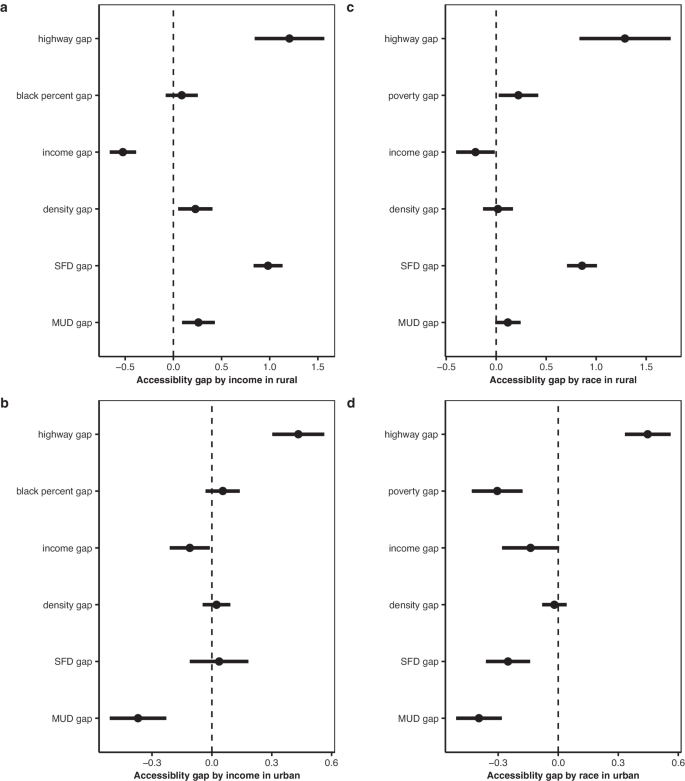
Infrastructure gap by income with coefficients of influencing factor (n = 2362 in rural areas in panel a, n = 2348 in urban areas in panel b). Infrastructure gap by race with coefficients of influencing factors (n = 1937 in rural areas in panel c, n = 2358 in urban areas in panel d). All the variables, except for the outcome variable, are normalized before running the regression. The black dots indicate the changes in EV infrastructure gap obtained from running separate regression analyses. The black horizontal bars represent the 90% confidence intervals of the estimations. Therefore, data are presented as coefficient values+/−1.65*standard error. “MUD” means multi-unit dwelling and “SFD” means single-family dwelling.
To provide a visual representation of our regression-based framework for the accessibility gap between Black and White households, we present Figs. 4c and 4d. Our results indicate that the highway gap is the primary contributor to the accessibility gap, followed by the income gap. Moreover, we observe that the poverty gap between Black and White households (i.e., the ratio of the poverty population in each group) also plays a significant role in contributing to the accessibility gap, but in opposite directions in rural and urban areas. Specifically, larger poverty gaps increase the accessibility gap in rural settings, while decreasing it in urban settings. Once again, we observe opposite signs for MUD gaps and SFD gaps between the rural and urban settings. This finding is likely due to the distribution of public charging stations around MUD areas in urban areas, where there is also a larger poverty population.
Overall, our results highlight the significant role of the highway gap, income gap, and poverty gap in determining the accessibility gap between LMI and non-LMI residents, and Black and White residents. They also demonstrate the importance of considering both MUD and SFD gaps in addressing the accessibility gap in both rural and urban settings.

Exploring Online Casino Gaming: A Guide to the Thrills and Strategies

The latest jobs in search marketing

Deloitte Ports and Freight Yearbook 2024: DAESCHI mid-year update | Infrastructure | Deloitte New Zealand

Dow soars more than 700 points to close at another record high

Albares reiterates Foreign Ministry recommendations to “travel safely” on holidays

Let’s take this offline: why indie fashion boutiques are back in fashion
:max_bytes(150000):strip_icc()/roundup-writereditor-loved-deals-tout-f5de51f85de145b2b1eb99cdb7b6cb84.jpg "I’m a Travel Writer, and Out of the 5 Million Prime Day Deals on Site, These Are the 12 I’m Shopping")
I’m a Travel Writer, and Out of the 5 Million Prime Day Deals on Site, These Are the 12 I’m Shopping

Military Installation Job Fairs: Setting Realistic Expectations for Veterans

Shooting at Baltimore’s Westside Shopping Center leaves man dead, two injured
