Bussiness
Houston deserves a much better electricity distribution system

In brief: Today’s post offers some thoughts about the need for a reckoning with power distribution in the greater Houston area, and greater resiliency given the conditions we regularly experience. In terms of a forecast, we will see additional thunderstorm chances today and Saturday before a hotter and calmer pattern begins Sunday.
Is this CenterPoint’s ERCOT moment?
Three and a half years ago nearly everyone in Texas had a bogeyman for the power issues that bedeviled the state during the Valentine’s Freeze of 2021. More than 4.5 million homes and businesses were left without power, and at least 250 people were killed directly or indirectly by the freeze. Property damages in the state approached $200 billion when “rolling” blackouts never actually rolled. It was a disaster—both natural and manmade.
The underlying issue was power generation, in particular the failure of power plants under extremely cold conditions, and an insufficient supply of natural gas for power plants. The reasons for this lack of preparation are complex, and partly political. The bottom line is that the organization tasked with supplying the vast majority of the state’s electricity and managing the grid, ERCOT, received the majority of the blame. This led to a reckoning for ERCOT and, at least theoretically, reforms that will prevent future issues. So far, so good.
The failure of Houston’s power grid during the derecho in May and, most recently Beryl, is a distribution issue rather than a generation issue. There was plenty of power available, it just could not be delivered to residents. There are three electricity distributors in the Houston region: CenterPoint, Texas-New Mexico, and Entergy. However by far the largest distributor is CenterPoint, which has drawn the lion’s share of angst and anger since the outages began early on Monday morning. Let’s face it, being without electricity, especially in the middle of July in Houston, is absolutely miserable.
We have been pretty clear here at Space City Weather that the region should not have experienced such widespread outages. Beryl knocked out electricity to more customers than Hurricane Ike did in 2008. At Beryl’s peak, 85 percent of CenterPoint customers lost electricity. This matters because Ike was much larger and more powerful than Beryl, and brought hurricane-force sustained winds across large chunks of the Houston metro area. I’m not saying Beryl wasn’t a nasty storm, but its winds were quantitatively, and significantly, less than those of Ike.
I am far from an expert on the distribution infrastructure that delivers power into homes. It is complex, and I salute the linemen working long hours to restore service. However, Houston’s electricity distribution system is not working. It is failing us. Many residents have now experienced two prolonged outages in three months. I realize that CenterPoint can no more control the weather than I can. But after Hurricane Ike our system should have been hardened for future similar (and lesser events, like Beryl). I realize there are no easy solutions, but there are things we should be studying and the implementing, such as concrete poles, underground lines, microgrids, and other ideas.
Whatever company officials and politicians say in the coming days, the harsh reality is that our transmission system failed the Beryl test. Badly. And if we do nothing it will happen again and again.
Just as ERCOT faced a reckoning after the great freeze, our distributors need a reckoning after Beryl. The status quo, and political leaders who enable it going forward, are unacceptable. What we have seen this week is unsustainable for a city that bills itself as the energy capital of the world.
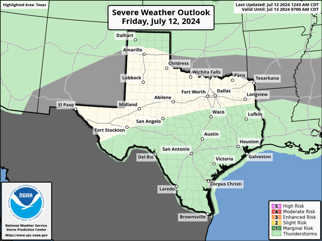
Friday and Saturday
Parts of the Houston area saw rain showers on Thursday, and some of these developed into fairly strong thunderstorms. A few locations just west of downtown picked up 1 to 1.5 inches of rainfall. This overall pattern of plenty of moisture in the atmosphere and an unstable boundary will persist today and Saturday. Therefore we are likely to see a similar pattern for the next two days, with showers developing near the coast later this morning and migrating inland this afternoon. Unfortunately, a few areas within these stronger storms will see lighting and briefly strong winds.
The upside to this pattern is partly to mostly cloudy skies, with cooler temperatures. Highs both days will be around 90 degrees, with light winds from the southeast. Overnight lows will generally drop into the upper 70s.
Sunday
By the second half of the weekend, high pressure should expand into Southeast Texas, setting the stage for a warmer pattern. We can expect mostly sunny skies and high temperatures in the mid-90s. Rain chances will be low, perhaps 20 percent, but not non-existent.
Next week
Hot, full-on summer weather arrives next week and our region will need electricity fully restored to cope. We are looking at highs generally in the mid- to upper-90s for most of the area, with mostly sunny skies. The first half of the week should be rain free, although chances for some scattered showers arrive during the second half of the week. Rain chances may improve further by next weekend as some sort of dying front approaches the region. We shall see.
To the extent possible, have a great weekend everyone. After a long period of activity, this site will go quiet on Saturday and Sunday, and then following our normal schedule of daily posting next week.


Exploring Online Casino Gaming: A Guide to the Thrills and Strategies

The latest jobs in search marketing

Deloitte Ports and Freight Yearbook 2024: DAESCHI mid-year update | Infrastructure | Deloitte New Zealand

Dow soars more than 700 points to close at another record high

Albares reiterates Foreign Ministry recommendations to “travel safely” on holidays

Let’s take this offline: why indie fashion boutiques are back in fashion
:max_bytes(150000):strip_icc()/roundup-writereditor-loved-deals-tout-f5de51f85de145b2b1eb99cdb7b6cb84.jpg "I’m a Travel Writer, and Out of the 5 Million Prime Day Deals on Site, These Are the 12 I’m Shopping")
I’m a Travel Writer, and Out of the 5 Million Prime Day Deals on Site, These Are the 12 I’m Shopping

Military Installation Job Fairs: Setting Realistic Expectations for Veterans

Shooting at Baltimore’s Westside Shopping Center leaves man dead, two injured
