World
Another searing day in Delhi, ‘real feel’ hits 50°C

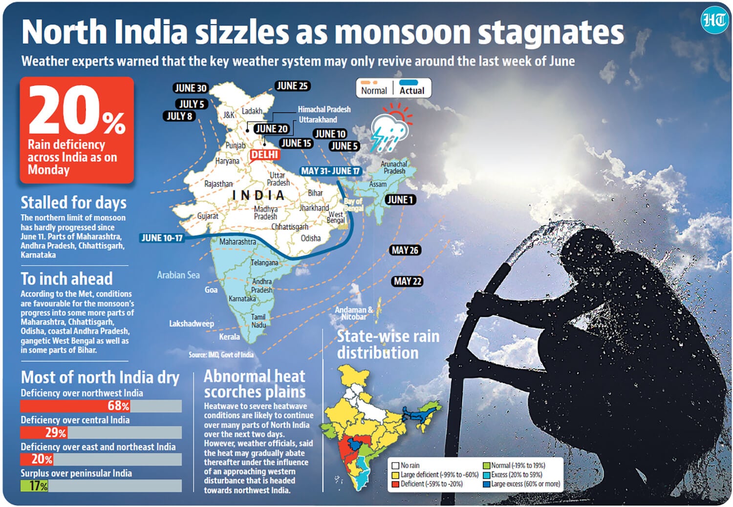
Delhi residents continued to endure torrid weather conditions on what was the ninth consecutive “heatwave” day on Monday, India Meteorological Department data showed, with some parts of the city even recording severe heatwave conditions.
The minimum temperatures clocked at night, which people look to for relief, barely improved the situation as the Capital logged its fourth consecutive “warm night”.
Safdarjung, representative of Delhi’s weather, recorded a high of 45.2°C — six degrees above normal — but the heat index (HI) or “real feel”, which accounts for humidity, came to a blistering 50°C.
Some weather stations recorded “severe heatwave” conditions — Jafarpur in southwest Delhi was the hottest with a maximum temperature of 46.9°C. This was followed by a maximum of 46.5°C at Pitampura, both over 8 notches above normal.

The minimum was recorded at 33°C — five degrees above normal for this time of the year. This was the longest streak of “warm night” conditions — the highest for June in at least 12 years. A day earlier, the minimum was 33.2°C and the maximum was 44.9°C. IMD classifies it as a “warm night” when the maximum temperature is over 40°C and the minimum is 4.5°C or more above normal. In June 2018, Delhi recorded three consecutive “warm nights” between June 13 and 15. Heatwave conditions, meanwhile, occur when the maximum is over 40°C, while also being 4.5°C or more above normal.
The Met department has issued a “red alert”, forecasting similar weather on Tuesday, before a brief relief from Wednesday due to an approaching western disturbance — which may bring light rain to parts of Delhi.
“The winds are dry westerly and occasionally southwesterly, which bring some moisture. There has been a marginal increase in humidity in the last 24 hours, which has raised HI,” said an IMD official, adding that the impact of the approaching western disturbance might lead to a slight drop in maximum temperature.
The HI, or “real feel” temperature, is a calculation that depicts what the temperature feels like to the human body when relative humidity is combined with the air temperature and wind speed. It is commonly used to assess the risk of heat-related illnesses and heat stress. Prolonged exposure to an HI of 26-32°C can cause fatigue, while 40-54°C is associated with heatstroke.
The relative humidity on Monday oscillated between 24% and 48%. The wet-bulb temperature, another indicator of the comfort level outside, was between 26.5°C and 27°C on Sunday. A wet-bulb temperature of 32°C or higher makes it difficult for people to work outdoors for long.
“The sky will remain clear on Tuesday. There are chances of heatwave conditions in most areas and ‘severe heatwaves’ in isolated areas along with ‘warm nights’. There are chances of strong surface winds, occasionally gusty winds of up to 30-40km/hour during the day,” the official added.

Exploring Online Casino Gaming: A Guide to the Thrills and Strategies

The latest jobs in search marketing

Deloitte Ports and Freight Yearbook 2024: DAESCHI mid-year update | Infrastructure | Deloitte New Zealand

Dow soars more than 700 points to close at another record high

Albares reiterates Foreign Ministry recommendations to “travel safely” on holidays

Let’s take this offline: why indie fashion boutiques are back in fashion
:max_bytes(150000):strip_icc()/roundup-writereditor-loved-deals-tout-f5de51f85de145b2b1eb99cdb7b6cb84.jpg "I’m a Travel Writer, and Out of the 5 Million Prime Day Deals on Site, These Are the 12 I’m Shopping")
I’m a Travel Writer, and Out of the 5 Million Prime Day Deals on Site, These Are the 12 I’m Shopping

Military Installation Job Fairs: Setting Realistic Expectations for Veterans

Shooting at Baltimore’s Westside Shopping Center leaves man dead, two injured
